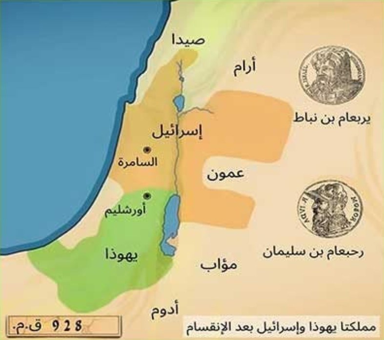
The Israeli Foreign Ministry shared a map showing the Kingdom of Israel, which is believed to have existed before Christ, through its Arabic social media account. The United Arab Emirates (UAE), Saudi Arabia and the Arab League condemned the publication of the map, which shows the lands of Palestine, Jordan, Lebanon and Syria, defined as the Bilad al-Sham countries, within Israel’s historical borders.
A post made by the Israeli Foreign Ministry’s social media account, which shares posts in Arabic, drew a reaction. The post, which defined the region including part of the occupied Palestinian territories, as well as Jordan, Lebanon and Syria, as the “Historical Israeli lands”, included a 3,000-year-old map.
Did you know that the Kingdom of Israel existed 3000 years ago?” In the post made with the question, the lands of Palestine, Jordan, Lebanon and Syria, known as the countries of Bilad al-Sham, are shown within the historical borders of Israel.

REACTION FROM ARAB COUNTRIES
In a statement made by the UAE Ministry of Foreign Affairs, it was emphasized that “provocative practices that violate international legitimacy decisions” were rejected. It was noted that the sharing of maps claimed to be “historical” by official accounts affiliated with the Israeli government and that included the occupied Palestinian territories as well as some parts of Jordan, Lebanon and Syria was condemned in the strongest terms. The statement, which drew attention to the fact that the posts “constitute a clear violation of international laws,” warned that such attitudes “threaten a more dangerous tension and hinder efforts to establish peace and stability in the region.” The statement emphasized “the need to support all regional and international efforts to advance the peace process in the Middle East as well as to end illegal practices that threaten the two-state solution and the establishment of an independent Palestinian state.” The Saudi Arabian Ministry of Foreign Affairs also stated in a written statement that they rejected the invalid maps and claims shared by Israel on its official accounts. It was reminded that the invalid map in question showed the territories of Arab countries Jordan, Lebanon and Syria within Israeli borders, and said, “Such radical claims are an indication of the occupation authorities’ intentions to consolidate their occupation and continue their attacks on countries’ sovereignty in violation of international norms.” The statement requested the international community to end Israel’s violations against the countries and peoples of the region. On the other hand, Arab League Secretary General Ahmed Abu Gheit condemned the posts in a written statement, stating that “the Israeli government’s attitude should be read in the context of extreme right-wing extremism and religious obsession.”
WHAT IS BILAD AS-SHAMMAD? Bilad as-Sham is a name given to a large geography encompassing four countries: Syria, Palestine, Lebanon and Jordan. This geography is called Bilad as-Sham, or the Towns of Damascus, because its capital city is Damascus in most periods. Syria has neighbors with Lebanon, Israel and Jordan to the south. Its only neighbor to the east is Iraq. It has a coast to the Mediterranean to the west. Two-thirds of this geography is covered with desert. The Nusayriya Mountain Range, Mount Jabal Saman, Mount Qasiyun, Mount Turkmen, Arvad Island, the Orontes River, the Euphrates River and Lake Al-Asad are located in this geography.

MINISTER FİDAN AND ŞARA DRANK TEA
Minister of Foreign Affairs Hakan Fidan drank tea with the leader of the new administration in Syria, Ahmet al-Şara, on Mount Qasiyun facing Damascus.


